2023 Osyooos Eagle Bluff Fire
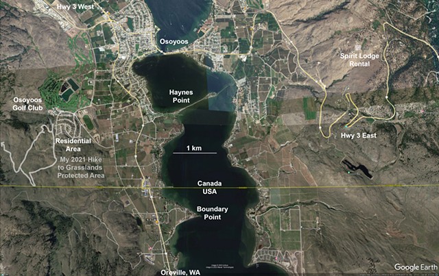
Osoyoos is a town in the Okanagan of BC on a lake of the same name which flows into the US at the town of Oroville, WA. This annotated Google Map shows the lay of the land. BC Highway 3 wiggles from West (left) to East (right), crossing a bridge of hotels in Osoyoos. On the East side, it curves up the side of Anarchist Mountain, on which Spirit Lodge is found. We stayed in Spirit Lodge hosted by the owners Karen and Hermann. Our suite had a deck facing US Boundary Point about 45 degrees south of west.
On the East side of the lake, Highway 97 runs North to South through Osoyoos and Oroville. To the west of Highway 97 and South of Highway 3 are some residential areas and the Osoyoos Golf Club. The residences in this quadrant were evacuated on the first night of the fire (Saturday), with residents returning a few days later.
I have shown a scale bar for 1 km. The fire was 5-7 km from our vantage point and never seemed to pose any immediate threat provided the wind did not change to come from the West.
It happens that I hiked in the area of the Canadian fire near these residences in the loop shown on the map, climbing to an elevation to the West of the left edge of the map. That territory is steep with some gravel logging roads and is characterized by dry grasses, sage and antelope brush 2 to 3 feet high and a few scattered pines in singles or small groups. Osoyoos is in the northern-most part of the Sonoran desert, which extends down to Mexico through Arizona and parts of California, so it is very dry in the summer.
This post shows images in chronological order.